Catawba river basin hits Stage 2 drought: What it means for water restrictions across the region
Mandatory water-use restrictions with costly fines
CHARLOTTE, N.C. (WBTV) -Several counties and cities have imposed mandatory water restrictions after worsening drought conditions pushed the Catawba River Basin into Stage 2, meaning violations can now come with possible fines.
As of May 1, Iredell, Caldwell and Catawba counties -- and cities including Gastonia, Charlotte, Hickory, Morganton, and Lenoir -- have announced required limits on water use.
Fines for violating water restrictions start at $100 and range up to $600 in some areas.
Beyond fines, officials from the Charlotte fire department said in a statement “Charlotte Fire relies on that system every day. Managing water use now helps ensure it is there when it matters most.”
Read more: Exceptional drought prompts Charlotte to impose mandatory water restrictions
More communities are expected to set mandatory restrictions in the coming days after the Catawba–Wateree River Basin entered Stage 2 drought under the region’s “Low Inflow Protocol.”
The decision to move to Stage 2 was made by the Catawba–Wateree Drought Management Advisory Group, a local coalition of cities and industries -- including Duke Energy -- that rely on water from the basin.
This group coordinates shared guidance for the Catawba basin which supports drinking water, industry, and downstream flow needs across North and South Carolina.
What (and where) is the Catawba–Wateree River Basin?
The Catawba–Wateree River Basin provides drinking water to more than two million people across 24 counties in North and South Carolina.
The basin begins in the Blue Ridge Mountains, runs through the Charlotte metro, and flows into South Carolina. It includes thousands of miles of creeks and tributaries, along with multiple dams and major lakes such as Lake Norman and Lake Wylie.
Worsening drought conditions have led to low inflow for the basin, meaning there is not enough water entering the basin to sustain normal water use for the communities that depend on it.
As exceptional drought spreads, the advisory group and local governments have moved into Stage 2 of the drought management plan “Low Inflow Protocol.”
What is the ‘Low Inflow Protocol’?
The Catawba-Wateree River Basin operates under drought-response guidelines known as the “Low Inflow Protocol,” which establishes water-reduction measures during periods when inflow to the Catawba basin drops significantly.
The Low Inflow Protocol stages are determined by three key indicators:
- How much water is in the reservoirs
- How much water is flowing into the reservoirs
- The U.S. Drought Monitor, a government site that tracks where drought is occurring and how severe it is
As of May 1, those indicators met the threshold for a Stage 2 declaration of the five drought stages, shifting the region from voluntary conservation to mandatory restrictions.
What is Stage 2?
Stage 2 aims to reduce overall water use by 5% to 10% to preserve reservoir storage, sustain downstream flow needs, and maintain drinking water availability across the basin until conditions improve.
Local governments are asking residents to reduce non-essential water use to protect the region’s water supply, specifically from the Catawba–Wateree basin.
Several regional counties have followed the advisory group’s guidance and implemented mandatory water restrictions, including Iredell and Catawba counties and cities such as Gastonia, Charlotte, Hickory, Morganton, and others
Meanwhile, some areas continue to remain under Stage 1 restrictions, which are voluntary.
Read previous coverage: Gastonia urges voluntary water conservation after Stage 1 drought declared: What this means
How bad is the drought?
Most of North Carolina had been in extreme drought as of April 2026, with the rest of the state one level lower in severe drought. However, the latest Drought Monitor shows exceptional drought has been introduced into four local counties for the first time since 2008:
- Mecklenburg County
- Cabarrus County
- Stanly County
- Union County

It has been since 2008 that any county in the Charlotte area and surrounding regions has seen exceptional drought.

Drought severity is described using these categories:
- Abnormally dry
- Moderate drought
- Severe drought
- Extreme drought
- Exceptional drought
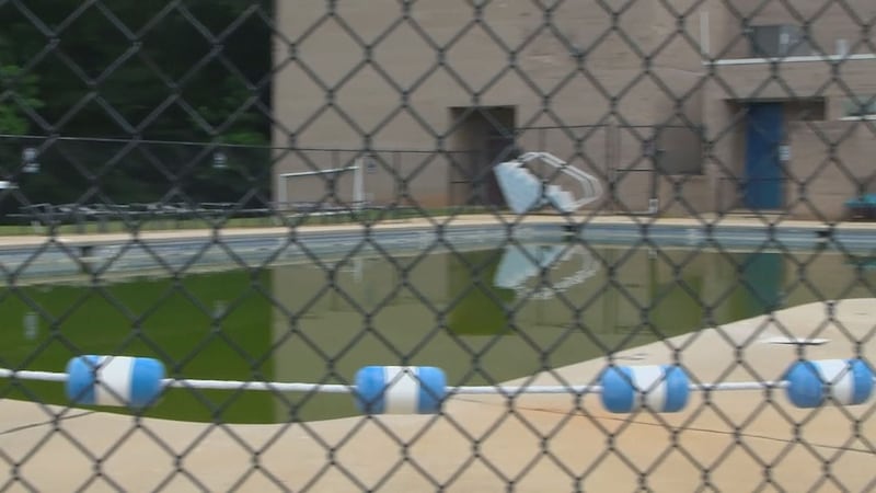
Severe drought can make water shortages more noticeable as stream flows drop, crops and lawns show stress, and communities may begin or expand water-use restrictions.
Extreme drought is more serious: waterways and reservoirs can fall sharply, burn bans become more likely, and wildfires can be harder to control and extinguish.
Exceptional drought includes all of these impacts and more.
Read more: Part of Charlotte area in ‘exceptional’ drought for first time in 18 years
Historically, daily life is typically affected at this stage, with crop loss and added stress on farmers becoming evident. Reservoirs, well water, and lake levels are low—and mandatory restrictions often come into play.
Most of North Carolina falls into the extreme drought category, with another large portion in severe drought.

How unusual are these conditions?
Statewide maps show North Carolina, South Carolina, and Georgia have seen record-dry conditions since September 2025, based on records dating back to 1895.
According to a WBTV meteorologist Rachel Coulter, even with several rounds of rain moving over the region, the rainfall deficit remains high because rainfall totals have stayed fairly low.
To end the drought within a month, the Charlotte metro would need more than 14 inches of rain.

Coulter also pointed to the 2007–2008 drought as a reference point: 2007 started strong, but the rain deficit grew through summer, and extreme-to-exceptional drought developed by fall and winter.
Closer-to-normal rainfall returned in 2008, but it still took until the fall to see major improvement.
For specific guidance on water-use restriction, check with your local county or city government.
Read more: Drought worsens across Charlotte region ‘exceptional’ drought declared in 4 counties
Copyright 2026 WBTV. All rights reserved.